
When it comes to the planning and design of new cycleways in London, two things have dramatically changed since March 2020: firstly, Transport for London (TfL) have had to tighten their belts, resulting in fewer planned large-scale cycleway schemes, and secondly, in an attempt to ‘build back better’ numerous new low-traffic neighbourhoods (LTN) have been implemented by councils, making backstreets a lot safer for cyclists. In response to these changes, TfL are looking to design a number of easy-to-deliver cycleways, taking advantage of the large swathes of London now covered by LTNs.
The transport body already has around 50 ideas for these schemes, known in some circles as ‘land grabs’. These vary between those just needing wayfinding (e.g. a route that is already of a high quality) and those that need some minor intervention (e.g. a new contraflow or a crossing over a main road). The first of these schemes, Cycleway 48 (Clapham – Brixton – Herne Hill), has already been delivered, with others to follow later this year.
Last month (January 2023), SafeCycleLDN and the London Cycling Campaign had a meeting with TfL to share ideas for potential ‘land grabs’. Those thought of by SafeCycleLDN were inspired by three things: firstly, the desire to create feeder routes to the main cross-borough cycleways (e.g. C2, C3 and C9); secondly, to create neighbourhood routes that could connect local town centres; and thirdly, to signpost TfL routes that have already been built, with a focus on the Central London Grid (2013).
The meeting went incredibly well, with TfL’s cycling team showing a clear willingness to work with the wider cycling community in this endeavour. Moreover, it was a relief to find out that while some of our ideas were already being considered (as they’d identified them beforehand), others were completely new for them, resulting in another ten or so being added to their list. This means that hopefully, in the next year or two, a couple of the ideas reviewed below, might become reality.
SafeCycleLDN’s land grab ideas
CLICK HERE TO SEE THE ACCOMPANYING LAND GRABS MAP
The ‘land grab’ ideas reviewed in this section have been graded in terms of how easy they would be to implement, starting with the simplest.
Kingston Station – Ham (or Cycleway 29 northern extension)
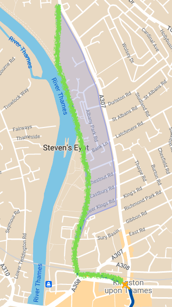
To create a comprehensive cycle network in Kingston, it is essential for there to be safe ways in and out of the town centre. One such route is Kingston Station (C29) to Ham (at the junction between Lower Ham Road and Richmond Road). In recent years this route has become a lot safer through the implementation of traffic filters around Lower Ham Road and a new pedestrian/cycle bridge next to the station.
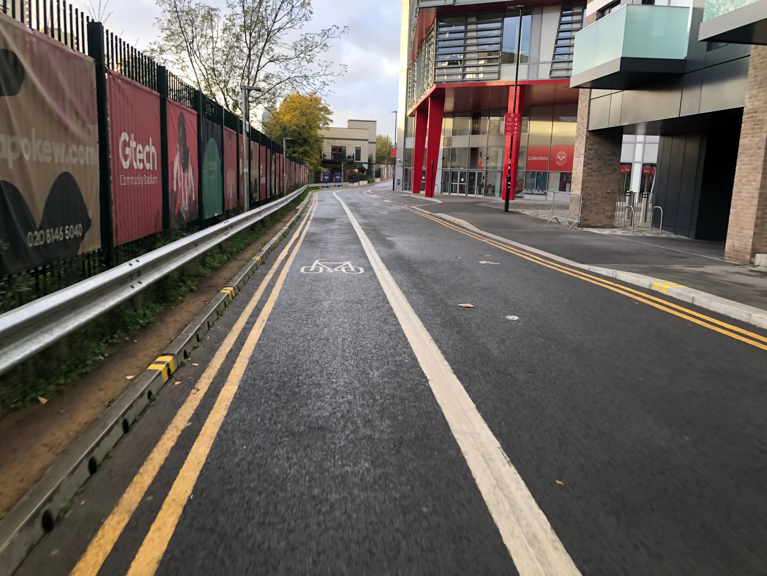
This is an incredibly easy win for TfL as all they need to do is make people aware of where the route is with wayfinding (signs, paint on the road, online maps).
jsdfasjdnfsdksjdnfkjsdnfksdjnfksdjfnvksjdfnvkjsdnfvsjdnfkvjsdnfksj
Quick win 10/10
Tottenham Hale (C1) – Wood Green – Highgate
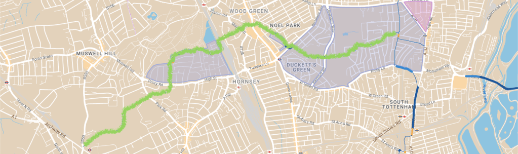
When legacy London Cycle Network (LCN) routes meet (or come close to meeting) modern day safety standards, there is no reason for them not to be brought into the capital’s official cycleway network. Tottenham Hale to Highgate is a good example of this, mostly following the old LCNs 53 and 7. What has made these old LCN routes viable as ‘land grabs’, is the recent creation of multiple low-traffic neighbourhoods.
This is an easy win for TfL to create a safe east-west route in a part of London that is infamously hostile to cyclists. What is remarkable is that all that is needed is official TfL wayfinding (signs, paint on the road, online maps), informing people of where the route is. What’s even better, is that it connects with Cycleway 1 in the east, the future Cycleway 38 in the middle and the future Barnet to Alexandra Palace Cycleway in the west. This would help tie a number of future and existing TfL cycleways, a big step in the creation of a comprehensive cycle network in north London.
Quick win – 10/10
Central London Grid

The Central London Grid is a 2013 plan for cycle routes around inner London. Since its publication, parts of it have been delivered, primarily as part of larger designated cycleways, such as C13 and C27. However, outside of these there are a small number of links that have been built incrementally over the last decade, with only wayfinding now missing. These should be signposted and made part of TfL’s cycle network. After all, they did plan and fund them. A few of these are:
- Waterloo (C5) – St Thomas’ Hospital (C56)
- Southwark Bridge Road (CS7, C10) – Tate Modern
- Lower Thames Street (CS3) – Houndsditch (with a potential future extension to Liverpool Street)
Quick win – 10/10
Kingston (C29) – Berrylands

The link between Kingston and Berrylands is a good example of an old LCN route (LCN 75) that could easily be brought into the TfL cycleway network.
Although the route has been good for many years, two recent additions have made it even better: the safe crossing at Villairs Avenue (2017) and the creation of the Fairfield Park low-traffic neighbourhood (2020). Moreover, due to improvements made across the whole of Kingston under the Mini Holland programme, it now connects at its northern end to C29 and C30, opening up multiple onward connections around the Royal Borough of Kingston.
Other than wayfinding, the only work that might be needed is traffic calming along on Grove Lane.
This is another easy win that TfL could implement with very little money, embellishing further the already extensive TfL Mini-Holland network in Kingston.
Quick win 9.5/10
Cycleway 29 southern extension

This is a good example of a scheme that could enhance an existing main road cross-borough cycleway: Cycleway 29 (which once finished, will connect Kingston and Tolworth). Currently C29 ends at the top of Tolworth Broadway, however, using existing infrastructure (with a few minor safety improvements), all that is needed is wayfinding to bring people safely across the A3 trunk road. This would create connections to the large LTN around Waddon Drive South, as well as West Ewell and Stoneleigh.
fdjkvndfkjvnsdfkjvnsdkfjnvskdfjnvskdjfnv fkjnvskdfjnvksjdnfvkjsdnfvkjsndf zdkfjnvskdfjnvskdjfnvksj kdfjnvskdjfkjnkjnkjnkjnkjnkjnkjnkjnkjnkjnkjnkjnkjnkjnkjnkjnk
Quick win: 9/10
Euston – Camden

In 2020, TfL constructed pop-up cycle tracks along Hampstead Road. In the same year, the London Borough of Camden created three low-traffic neighbourhoods around Arlington Road. These schemes could be easily joined up, creating a safe cycleway between Euston and Camden.
As left turns from Hampstead Road into Mornington Crescent are banned for vehicles, all that is required is the transformation and extension of the current zebra crossing at this location, allowing cyclists heading south to get from the filtered Mornington Crescent onto the Hampstead Road cycle tracks.
Making this improvement would not only create a new route from Euston to Camden (avoiding the daunting Camden High Street), but also enrich the work already done by TfL on Hampstead Road, which currently connects to nothing.
Looking even further ahead, if this cycleway was created, there would be scope one day to connect it to the Gower Street cycle tracks (C47), which would result in a cycleway all the way from Soho to Camden.
Quick win: 9/10
Hammersmith (C9) – Shepherd’s Bush (C34)
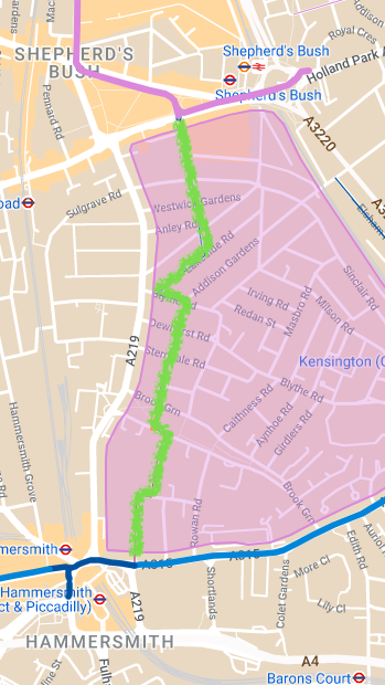
Shepherd’s Bush to Hammersmith is not only an obvious neighbourhood route, but also a good example of a connection to not one, but two, major cycleways (C9 and the future C34). Even better, there is already an almost complete backstreet route which uses a number of small legacy interventions, resulting in only contraflows along Bute Gardens and Luxembourg Gardens being required. What makes this route possible however, is the creation of the Brook Green and Olympia Area Clean Air Neighbourhood, which once implemented, will drastically reduce the amount of traffic along these streets.
If the main route is delivered, there is further scope to create a branch to Royal Crescent, running along Addison Gardens, Holland Villas Road and Addison Road.
Quick win: 9/10
Central London Grid: Vigo Street

Unlike the Central London Grid routes mentioned above, this example requires a little bit of work: namely, the installation of a contraflow on Brewer Street. This would logically follow the filter built on Vigo Street (2021) and the improvements to the junction with Regent’s Street (late 2022), creating a useful connection between Mayfair and the future Pimlico to Fitzrovia Cycleway.
Quick win: 9/10
Walworth (C17) – Brixton (C48) / Loughborough Junction

With the emergence of new low-traffic neighbourhoods in Southwark and Lambeth, a new route has emerged that safely connects Walworth (C17) with Brixton (C48) and Loughborough Junction.
The main route (Walworth – Brixton) only requires a contraflow along Patmos Road/Elliot Road and the creation of a safe way for cyclists to get in and out of the northern end of Fiveways Road. The branch to Loughborough Junction is dependent on the already funded segregated tracks along Loughborough Road being constructed.
This route would provide a pleasant backstreet alternative for those travelling from Brixton/Loughborough Junction into Central London: very much a quick win.
Quick win: 8/10
South Lambeth (C5) – Walworth (C17) – Burgess Park (C35)

South London is already served by a number of north-south backstreet cycleways, with the three mentioned in the title (C5 / C17 / C35) connecting the city centre with the inner suburbs. What this area lacks however is a good-quality east-west route, tying them all together.
This route is made possible by two soon-to-be-implemented LTNs in LB Lambeth, Slade Gardens and Myatt’s Fields. Alongside this, it uses legacy infrastructure and the main shared space path through Burgess Park. The only interventions required would be, the transformation of the existing pedestrian-only areas (just north of Camberwell New Road) into shared spaces and a safe crossing between Caldwell Street and Albert Square.
Quick win: 8/10
Vauxhall Bridge – Victoria/Pimlico (Western extensions of the former CS5)

The popular Oval to Pimlico cycle track (formerly CS5) safely takes cyclists across the dangerous Vauxhall gyratory and Bridge. However, on the north side of the river, the cycle track abruptly stops at the junction with Regency Street, leaving cyclists heading north-east to either continue along the dangerous Vauxhall Bridge Road or try and find an alternative backstreet route. However, all parallel backstreets lack contraflows and other pro-cycling measures, leaving only those who know the area well to find a safe (and in reality, indirect) alternative.
The reason why there is a short, high-quality, segregated cycle path between Oval and south Pimlico is that it was originally going to be part of one of TfL’s Cycle Superhighways (CS5), connecting Victoria and Lewisham. This originally went out to consultation as a paint-on-the-road-only scheme (like CS7), but following the realisation that these were not particularly safe, the plan was transformed to accommodate segregated cycle tracks along the whole route. This was the first section built, however, following opposition to the likely loss of many miles of bus lane, the scheme was shelved. In 2022, the CS5 signage was removed and part of it (Oval to Vauxhall) was appropriated by C5 (Southwark to Clapham), with the stub to southern Pimlico becoming a C-Link.
What now remains, with this unfinished scheme, is a heavily used route that leaves cyclists in danger if they want to continue onto Pimlico or Victoria. Below therefore are two ways to improve this (at least until proper segregated cycle tracks can be built along Vauxhall Bridge Road and/or Belgrave Road). Neither require much work, nor disrupt any other transport modes.
Route 1 – A safe connection to Pimlico town centre
- There is already safe provision from the cycle track into Bessborough Street;
- Wands would be needed along Bessborough Street up to Rampayne Street;
- The existing pelican crossing at the southern end of Tachbrook Street would need to become a toucan crossing. Alongside this, the wide pavement buildout between Bessborough Road and Tachbrook Street would need to be turned into shared-space;
- Tachbrook Street should also be filtered to remove any through traffic. In time it would also make sense to reduce the carriageway width on this road.
Quick win: 7/10
Route 2 – A safe connection to Victoria
- Part of Douglas Street and Vincent Square would need contraflows installed;
- A short section of segregated tracks (or pavement build-outs) would be needed on Rochester Row, to enable safe crossing from Walcott Street to Willow Place;
- A contraflow on Carlisle Place would be needed;
- (In future, a further link to CS3 could be created, however this would require more complex and costly interventions).
Quick win: 7/10
With very little intervention, both of these routes would enable cyclists (especially those who don’t know the area well) to continue their journeys safely from the end of this otherwise high-quality cycle track. Although in both cases, more than just signage is needed, it seems like such a waste to have a high-quality cycle track that at one end connects to nothing.
Kilburn High Road – Maida Hill
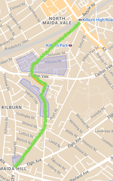
This is a perfect example of a neighbourhood route that could connect two town centres through pleasant backstreets and shared spaces. This idea works particularly well, as the current main road route is not only along hostile streets, but is also less direct than the backstreet option. The only thing that holds it back right now, is that it only works for those travelling south.
To make this route possible, a short northbound contraflow is needed from Walterton Road to Malvern Road, allowing safe crossing across the junction with Shirland Road. Alongside this, official permission would be required for cyclists to use the wide pedestrian space between Stafford Road and Malvern Road.
Quick win: 7/10
Clapham Common (C5 / CS7) – Brixton Hill
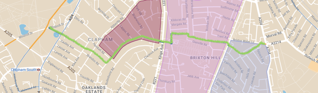
This idea already forms part of a legacy route – LCN 25 – and has been a popular connection for local cyclists in the area for many decades. Alongside this, it already has in place two safe crossings over main roads and will soon form part of the Brixton Hill LTN (set to be implemented in 2023). This makes it a prime target for TfL to consider.
The only intervention required would be a new filter between Crescent Lane and Park Hill (to ensure the streets in that area are completely free from through traffic) and a safer way for cyclists to get between Lambert Road and Josephine Avenue.
Quick win: 7/10
Tottenham Hale (C24) – Seven Sisters (C1)

This route has already been covered in the 2021 SafeCycleLDN article Missing Links on London’s safe cycle network. However, it is also a good example of an easy-to-deliver ‘land grab’, embellishing both C1 and C24. It should be noted that it would only act as an interim measure, as TfL has plans in the near future to bridge this missing link with segregated tracks along Broad Lane (as part of C50: Camden – Tottenham Hale).
The scheme wouldn’t require too much intervention, as most of the infrastructure is already in place. Therefore, all that is needed is: a contraflow on Tottenham Green East South Side; permission for cyclists to use the Broad Lane zebra crossing; and a safe way for cyclists travelling east to get from the Broad Lane pavement cycle tracks to the C24 eastbound cycle track.
Following the C23 western extension (currently under construction), this would provide a second much-needed connection from Waltham Forest’s Mini Holland network, to the rest of the capital’s cycleway network.
Quick win: 7/10
Wanstead – QE Olympic Park (C16)
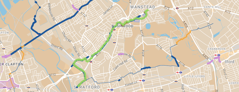
LB Waltham Forest have slowly been delivering this key east-west route since 2015, with the latest sections being constructed this year at High Road Leytonstone and Maud Road/Trelawn Road. Once these are complete only two small gaps will stand between there being a safe route from Wanstead to the QE Olympic Park.
The first is just north of the High Road Leytonstone section, where a small gap of about 150m of main road is currently without protection. In the short term, some interim safety measures could be put in place, such as traffic calming and wands, but ideally in future, stepped tracks should be installed. The second is the section next to George Green in Wanstead, where the pavement would need to be turned into a shared space. In time, this could also be improved and widened to better accommodate cycle traffic.
Completing these two final sections could bring Wanstead and Leytonstone into London’s wider safe cycling network. Moreover, it seems like a silly opportunity to miss, considering how much work has already been done.
Quick win: 7/10
Wembley – Harrow
(Possible extension of the planned Wembley to Willesden Junction Cycleway)

Since 2018, TfL have been planning a new cycleway between Wembley and Willesden Junction. Once this is complete, without much difficulty, an existing route up to Harrow could be linked to it.
It mostly follows LTNs and shared-space paths, however, some intervention would be required. This includes: minor safety improvements to the junction with East Lane (early release traffic lights and advanced stop lines); a new toucan crossing to safely get cyclists from Northwick Avenue to Gayton Road; and the transformation of the short passageway between Nathans Road and Byron Road into a shared space. The last intervention might cause some of difficulty, as TfL or the council could consider the path inappropriate as a shared space due to its narrowness.
If built, this could bring the TfL Cycleway network to Harrow, a part of London that currently lacks a TfL cycle route.
Quick win: 7/10
Addiscombe – Norwood Junction
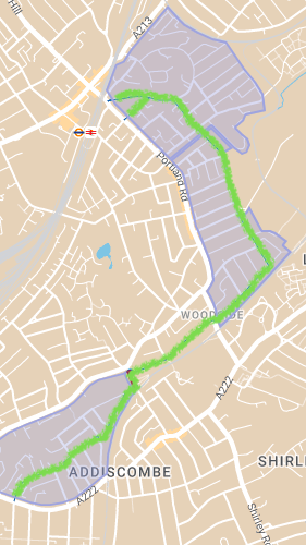
This route uses the Addiscombe Park and Albert Road LTNs to create a safe neighbourhood route between Addiscombe (near Croydon) and Norwood Junction. Other than wayfinding, all that is needed is the transformation of the pavements and zebra crossing on Blackhorse Lane into shared spaces. However, this job might be slightly more complex than it looks, as to meet TfL standards, the zebra crossing could need widening.
ggggmgjsfgkjb ksdjfvksjfnv fkjsdfkvskdfjnvksjdfnvkjdsnfv askdjnasdkjnckajsdnckjasndkcjnasdkjvn askdjnaksjdnckajsdnckjasndckjjkdjfnvksjdnfvkjsndfkvjnsdfkjvnsdkfjv ksdfnvaknvksjdfnvkjsdfnvkjsndfv k
Quick win: 7/10
Westminster (C3) – Elephant & Castle (C6/CS7) – Walworth (C17)
(or C56 eastern extension)

Cycleway 56 appeared in 2022, when the new protected tracks along Westminster Bridge created a safe link between Cycleway 3 (Westminster) and Cycleway 5 (Lambeth). Therefore, it only seems natural to continue this cycleway eastwards.
The proposed route would take it from its current terminus in Lambeth, to Elephant and Castle (CS7) and Walworth (C17), using primarily filtered roads and protected lanes. For this, two small and one large intervention would be required. The two small interventions would be: making the recently built cycle track between Cosser Street and Brook Drive two-way; and, making the footpaths between Hampton Street and Crampton Street shared space (also removing the barriers). The large intervention would be to find a safe solution to get cyclists from Brook Drive to the cycle track on Kennington Lane.
This scheme would create a useful east-west link out of Elephant and Castle, which is currently only served by north-south cycleways, making connections to places such as Westminster, Hyde Park Corner and Kensington.
Quick win: 6.5/10
Kew Bridge (C9) – South Ealing – Boston Manor
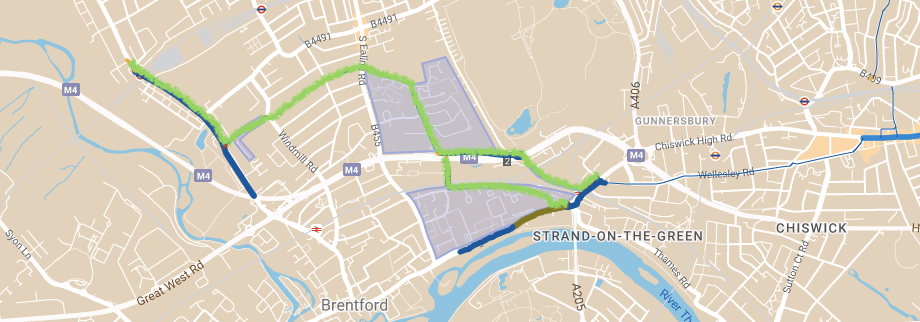
With all the money and energy over the last decade that has gone into delivering Cycleway 9, it only makes sense to use and improve surrounding infrastructure and identify safe connections from the cycleway to nearby neighbourhoods. This would inevitably allow it to be more useful to more people.
One such link could connect Kew Bridge to Boston Manor, via South Ealing. This would require intervention at a few points, but nothing too complex:
- The initial part of the route (between C9 and Clayponds Avenue has a choice of two alignments (both of which are shown on the accompanying map):
- Alignment 1 follows Lionel Road and the Great West Road. For this:
- The pavement between Capital Interchange Way and Lionel Road would need to be turned into a shared space. In time, the pavement at the corner of Kew Bridge Road and Capital Interchange Way could also be widened to better accommodate cyclists;
- At the north end of Lionel Road, there is already infrastructure in place to safely get cyclists across the A4. This might however need to be modernised to reflect the safety standards of the 2020s;
- Alignment 2 follows Green Dragon Lane and the pedestrian/cycle bridge over the Hounslow Loop). For this:
- The crossing just north of Kew Bridge and the pavement between that and Green Dragon Lane would need to be turned into shared spaces;
- Alignment 1 follows Lionel Road and the Great West Road. For this:
- At the end of Occupation Lane, it would cross South Ealing Road into Murray Road, perhaps requiring minor safety interventions to make the crossing safer;
- The junction crossing Windmill Road would require the largest intervention, a new junction that allows safe crossing for cyclists between Murray Road and The Ride;
- A toucan crossing should be added between The Ride and Boston Manor Road to facilitate safe crossing onto the existing Boston Manor Road cycle track.
This is one of the more complex routes suggested, although compared to many new cycleway ideas, it requires very little intervention, primarily using existing infrastructure. What is most useful about it is how it would allow those in Boston Manor, Northfields and South Ealing to safely connect to C9, allowing for safe journeys east towards Chiswick, Hammersmith and Olympia.
Quick win: 6/10
Barnes – Putney

This route already forms part of National Cycle Network 4, providing a safe backstreet link between two neighbourhoods, Barnes and Putney. Where it falls short is the unpaved and unlit section of river path, between Leader’s Gardens and Queen Elizabeth Walk. To make this route accessible to a wider range of cyclists, this short section of river path could be paved and lit, with the footpath section of Queen Elizabeth Walk potentially widened in future.
This cycleway would require slightly more complex intervention than others, although is an easy win in terms of not requiring any road closures or main road intervention. Another benefit is that the London Borough of Wandsworth plans to deliver cycle safety improvements around Putney Bridge, which together with this route, could facilitate safe journeys between Barnes and Wandsworth.
Quick win: 6/10
Whitechapel (C2) – Shoreditch
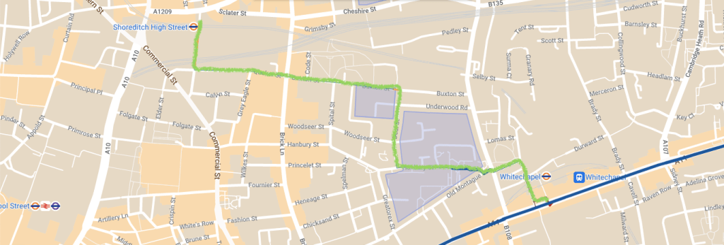
This is a good example of a feeder route that could embellish Cycleway 2 (the main-road protected cycleway between Stratford and the City), by creating a useful connection for those travelling west, to reach places such as Brick Lane and Shoreditch.
To make this idea work, four small interventions would be needed. The first (on a TfL road) would require the existing pedestrian crossing, immediately west of Whitechapel Station, to be turned into a toucan crossing. The following three (on LB Tower Hamlets roads) would require the creation of three short paint-on-the-road contraflows.
Considering how anti-cycling the new LB Tower Hamlets administration is, the lack of major intervention on borough roads is convenient. However, their general poor attitude towards safe cycling in the borough (seen in the current attempts to try and remove recently installed – and TfL-funded – LTNs and cycle tracks), understandably puts them on a bad footing with the capital’s transport body. This sadly means that there are many barriers in the way of this idea becoming reality.
Quick win: 6/10
Hammersmith Road (C9) – Earl’s Court

This is a good example of another feeder route to Cycleway 9, bringing all the benefits of TfL’s high-grade West London cycleway to the Earl’s Court area. The route theoretically already exists, although cyclists currently have to break a few rules to make it work. Therefore, this wouldn’t be too hard to rectify. All that is needed is the following:
- Safe entry from Cycleway 9 into Albion Road;
- A contraflow along Edith Villas;
- A safe cycle crossing over North End Road between the two halves of Edith Villas;
- The transformation of the north side of West Cromwell Road, across the railway bridge, from a pedestrian-space into a shared-space (if it is not already);
- The transformation of the crossing over Warwick Road into a toucan crossing.
Luckily, the rest of the route runs through one of the few low-traffic areas within the Royal Borough of Kensington and Chelsea (RBKC), meaning wayfinding installation would be the only thing required of them. This is beneficial because, just like Tower Hamlets, RBKC are vehemently anti-cycling.
Quick win: 5/10
Lancaster Gate (C3/C27) – Little Venice

Westbourne Terrace already has wide compulsory painted cycle lanes (dating from the pandemic), which continue north from the present terminus of Cycleway 3. These go on until just after the bridge over the Great Western Railway, where they awkwardly split depending on which direction one is travelling in – a failed attempt to overcome the car-centric infrastructure under the Westway.
The cycle lanes as far as the railway bridge could easily have wands added, bringing protected lanes as far as Royal Oak. Following this, a crossing could be made to allow cyclists going northbound, to head into Little Venice (currently only possible for those travelling south). This would open up journeys into the Warwick Avenue area, overcoming the GWR/Westway barrier.
Lastly, both Blomfield Road could be turned into a contraflow to make connections to Warwick Avenue and the Delamere Terrace pavement could be turned into a shared space (a 10-year old proposal), to make connections to the Grand Union Canal towpath.
Despite including a bit more intervention than some of the other ideas mentioned, this would not only open up safe journeys across Central London for those living north of the Westway, but would also embellish London’s best cycleway: C3!
Quick win: 5/10
Harrow – Stanmore/ Edgware
This proposal runs through a borough that is not keen on building any cycle infrastructure that negatively impacts car journeys. This neighbourhood route luckily gets around that by following existing LTNs, an old railway line and quiet backstreets. Although it requires a lot more intervention than any of the others discussed above (and is therefore a lot more complex than a ‘land grab’), it is in one of the areas of London that needs good infrastructure the most.
The first section of the route out of Harrow follows existing protected cycle lanes and LTNs, until Christchurch Road, where the pavement on the south side would need to be transformed into a shared space. The following section along the Belmont Trail would require the most work, paving it with a smooth and wide track that is properly lit at night. If initial funding is an issue, a cheaper option would be to only pave the Trail as far as Dobbin Close and then follow backstreets up to Vernon Drive. (This alternative route is shown on the map)
A small section of new paving would be needed to create a good quality shared pavement between Wemborough Road and Belmont Lane. However, after this (at least on the Stanmore branch) the route simply follows backstreets for the rest of the way. The Edgware branch is a little more complex, needing two toucan crossings to create a safe backstreet route. However, this branch could be implemented as a second phase, reducing the initial cost.
Quick win: 4/10
Other ideas
A number of other ideas are listed on the map under the heading ‘Routes that need more thought’. These are ideas that are either not fully fleshed out or are far too complex to be considered ‘land grabs’. Nevertheless, they could still provide a good base when considering new backstreet cycle routes in the long term. These include:
- Moorfields – Victoria Park (partly following the Central London Grid);
- Haggerston (C27) – Hoxton (C13) – Whitechapel (C2);
- Croydon – Carshalston;
- C23 northern extension to Woodford;
- Battersea Park (CS8) – South Lambeth (C5);
- Earl’s Court – Imperial College;
- Plumstead – Erith (potential C4 extension);
- Kensington Olympia (C9 and C39) – Kensington Church Street;
- Lewisham – Horn Park (for this to be possible the LTN would need to be reinstated).
Conclusion
In this review I’ve tried to show that there are multiple ‘land grabs’ in the capital that TfL could create. Some of them are only possible due to recent LTNs, while others have been there for years and just need to be better publicised. On top of this, some of them are ready to go (with only wayfinding needed), while others need a little work beforehand. What is clear in any case, is that there is a lot of low-hanging fruit lying around.
Now you may well ask why ‘land grabs’ are even necessary? Surely what we really need is more interventions on main roads. However, what must be remembered is that although TfL is designing and building main road schemes (C4, C9, C34 and C37, to name a few), they take a long time to deliver and cost a fortune to build. Therefore, considering the number of new LTNs that have been created since 2020 (and with many more on the way), it makes complete sense to also expand the backstreet cycle network. Doing so will not only make connections to existing main road cycleways better, but also bring the network to places that are currently unserved by it.

Great article.
LikeLiked by 1 person
Absolutely. Boroughs are attracted by high profile main road schemes but they often get horribly compromised due to parking issues.
Mind you back roads need filtering and there will be backlash on that.
LikeLiked by 1 person