
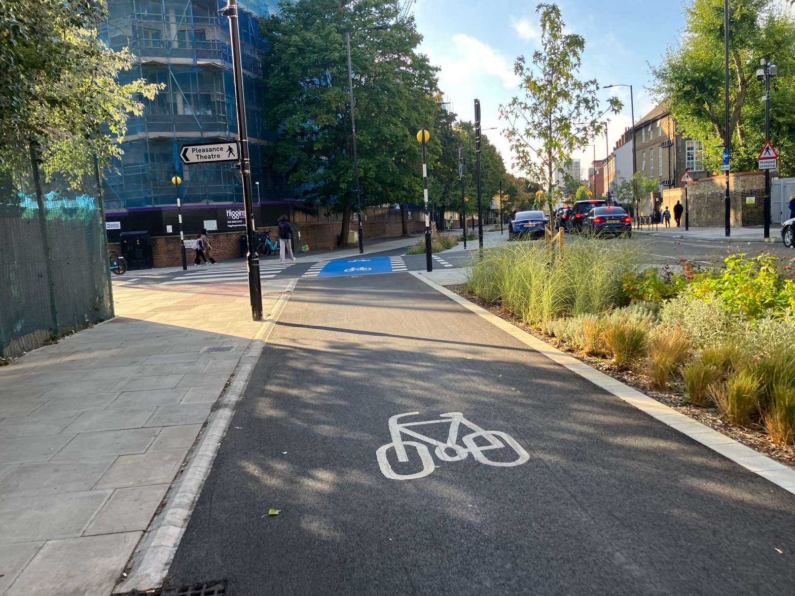
If you cycle regularly in London and have noticed the many gaps in the existing infrastructure, you may have wondered whether there is a grand plan for a city-wide cycle network – something akin to Paris’ Plan Vélo. The answer is frustratingly unclear. While several cycleways and low-traffic neighbourhoods are in the pipeline, since COVID, Transport for London (TfL) has been relatively unwilling to commit itself to any long-term comprehensive plan. This is partially due to the difficulties of working with certain anti-cycling boroughs, but also, as TfL is expected to fund itself, economic hits such as COVID and Crossrail delays have created financial instability which interrupts and disincentivises ambitious plans.
Nevertheless, this wasn’t always the case. Between 2009 and 2017, TfL released three separate ambitious plans for cycling: the Cycle Superhighways plan (2009), the Central London Grid (2013) and the Strategic Cycling Analysis (2017). What’s also remarkable is that none of them have ever officially been cancelled, with sections of them – however small – even being built each year. However, in the eyes of TfL, it is only the 2017 Strategic Cycling Analysis that’s still occasionally referred to, with neither the Cycle Superhighways plan nor Central London Grid being mentioned by TfL since 2019.
Despite this abandonment, all three plans have become part of the policy and institutional memory of London’s local authorities, with councils often taking the lead on their roll out (mainly through Local Implementation Plan applications). And while this may have led to a rather haphazard delivery, it does mean a city-wide network will continue to grow and inevitably be a reflection of all three proposed networks. To better understand how this might develop, we need to look in more detail at the three plans proposed.
Older networks, Mini Hollands/Liveable Neighbourhoods programmes and Quietways
The London Cycle Network (LCN), the National Cycle Network (NCN), and the London Cycle Network Plus (LCN+) will not be discussed. While some routes from these networks were well designed and have since been partially incorporated into more recent programmes, they were generally built to different safety and capacity standards than those expected today.
The Mini Hollands and Liveable Neighbourhoods programmes will also not be discussed, as despite them being funded by TfL, are not cross-borough networks. Lastly Quietways, although a cross-borough network, never had a comprehensive plan and rather acted more like a continuation/upgrade of the LCN/LCN+ programmes.
Cycle Superhighways
The Cycle Superhighway (CS) map is perhaps the closest London has come to having a Tube Map for bikes, showing a comprehensive plan of proposed radial routes connecting central London with the outer suburbs. Unlike earlier routes planned under the LCN, NCN and LCN+, they were designed to be direct and to handle high volumes of cyclists. The publication of this plan – and the delivery of the first CS routes – likely helped contribute to the increased number of cyclists seen in the early 2010s.
The first two Superhighways launched in 2010: CS3 (Tower Hill to Barking) and CS7 (City to Merton), with CS2 and CS8 following in 2011. And these would have been fantastic had they actually provided physical segregation from motor traffic.
This lack of foresight tragically came to a head in 2014, following six horrific deaths on CS2 over a four-year period. In response, over the next six years, CS2 was given physical segregation, as was the first – and only – part of CS5 (Oval to Pimlico). Alongside this, two new additional CS routes, the North-South and East-West Cycle Superhighways were built to a very high standard. However, because more extensive changes were now required to existing road layouts, other proposed CS routes were subsequently delayed, amended or cancelled.
Although the CS brand has been discontinued and TfL have not advertised the map since the mid-2010s, some routes from the plan are progressing (albeit slowly). CS4 and CS9 (now C4 and C9) are slowly getting built, as are parts of CS10 (now C34) and CS2 east (Stratford to Ilford), while some have been delivered but significantly watered down, like CS1. The remaining proposed Superhighways have been largely forgotten, like CS11 and CS12. Yet, the idea of a ring of radial routes clearly remains an ambition, even if some of the exact alignments proposed in 2009/2013 are never delivered.
As several proposal maps were produced between 2009 and 2013 – with differing route lengths and alignments – it is difficult to precisely measure the current status of the Cycle Superhighway network, however if we take two maps as a benchmark we can get reasonably close:
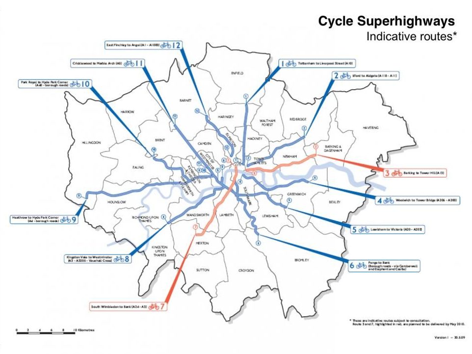
2009 map
Network length: 149.5km
Built: 48.3km (32.3%) – The surviving – original – non-segregated parts of CS7 and CS8 are not included
Parts consulted on/under construction: 19.82km
Total length when consulted sections are built: 68.12km (45.6%)
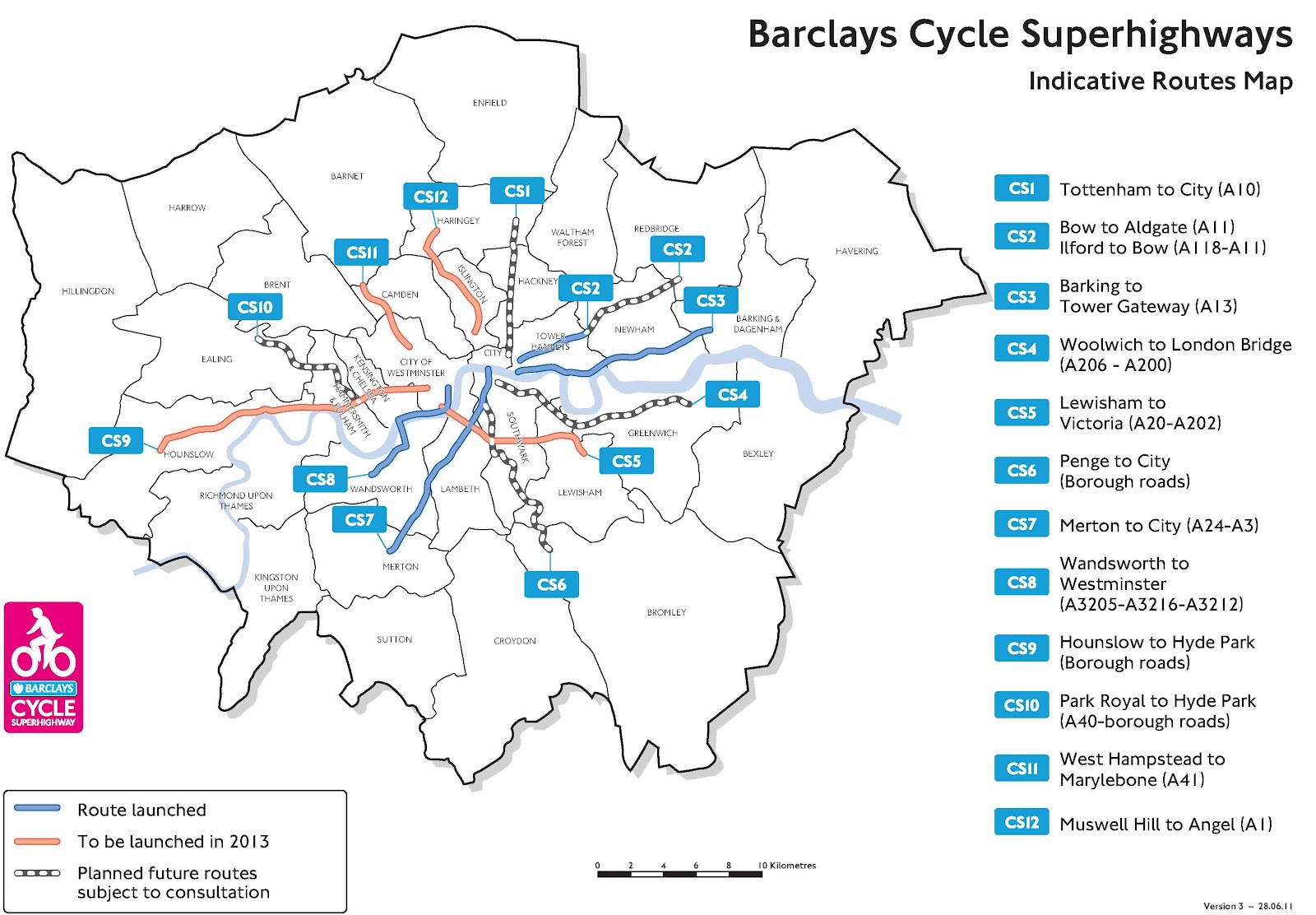
2012 map
Network length: 120km
Built: 46.22km (38.52%) – The surviving – original – non-segregated parts of CS7 and CS8 are not included
Parts consulted on/under construction: 15.98km
Total length when consulted sections are built: 62.2km (51.8%)
From this, it can be reasonably said that a third of the network is complete, and assuming the consulted sections are built by around 2030, about half the network will have been delivered. This is far from ideal, considering the plan will be almost a quarter of a century old by that point (the time it took to build most of the Docklands Light Railway), but at the very least, it seems in part to still be growing. After all, these high capacity main road routes have proved to be the hardest ones to deliver both financially and politically.
Central London Grid
The Central London Grid (CLG) was an ambitious report setting out TfL’s vision for an integrated cycle network in central London. The plan primarily focussed on backstreet routes, although the nine proposed Cycle Superhighways that entered central London also featured. The CLG didn’t necessarily suggest that routes needed to be segregated or filtered, but rather created a blueprint of where cycling should be easy and reasonably safe. However, with implementation largely left to councils, the quality of delivered routes has varied significantly.
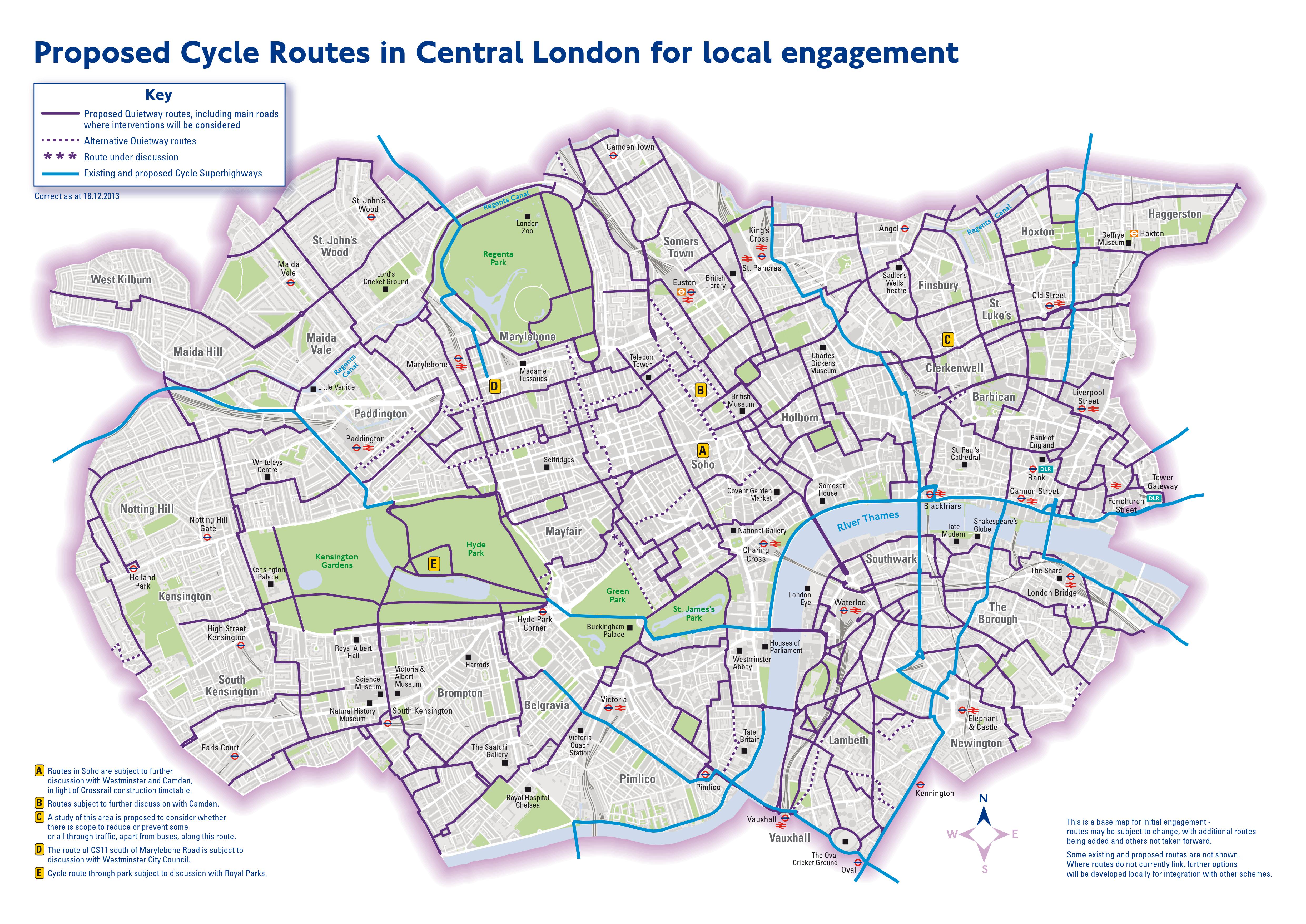
Progress has certainly not been easy. This is down to a number of reasons, although the fact that the CLG primarily runs down council roads (who own 95% of London’s streets) is the biggest one of all. Not only does each borough have different ideas of what a safe cycle route is, but they also work at different speeds and to different budgets. This means that while some local authorities, such as the City of London, LB Hackney and LB Lambeth, have made large strides in delivering their sections, others such as RB Kensington and Chelsea (RBKC) have dragged their feet. Moreover, it is worth noting that the sections that RBKC and Westminster have delivered have often been of a poorer quality (see Cycleway 27 across those two boroughs compared to the sections delivered by LB Camden and LB Islington).
All of these issues together mean that after twelve years, the CLG is still only around 50% complete. Performance also varies significantly between boroughs: Lambeth and Southwark have completed around 75% of their respective networks, while RBKC has only completed 37%. Nonetheless, despite the plan being dead in the eyes of TfL, the CLG continues to grow, with Westminster (during their short stint as a Labour authority) bringing some key projects forward. As a result, cycleways are currently being constructed along Lambeth Bridge, Westbourne Terrace, Little Venice, George Street (now Cycleway 43), Cleveland Street (now Cycleway 63) and a route between Marylebone and St John’s Wood (now Cycleway 51). If the new authority doesn’t rip any of these cycle lanes up and progress continues in other boroughs, once all the proposed/under construction sections of the network are delivered, the CLG will be almost 60% complete.
Strategic Cycling Analysis / Cycle Future Routes
The 2017 Strategic Cycling Analysis (SCA) and its Cycle Future Routes map (CFR) laid out the routes that TfL hoped to deliver by 2041. Part of this plan continued the Cycle Superhighway ambition of creating a network of radial routes, however it also suggested several orbital cycleways. These potential cycling corridors were split into three levels: Top, high and medium. The ‘Top’ 25 corridors were numbered, with the SCA stating that TfL would conduct feasibility studies for those routes over the following years.
The SCA explained its purpose as being to identify ‘potential corridors and locations where current and future cycling demand could justify future investment’. Compared to the Cycle Superhighways plan, this all together vaguer sales pitch was perhaps an acknowledgement of the difficulties TfL had encountered since 2010 in delivering main road schemes, but also could have been a reflection of the transport authority’s more precarious financial situation, having been forced to fund itself since the mid-2010s.
The first six routes to move beyond the ambition stage were announced by Sadiq Khan in 2018 and have since been partially delivered (with COVID delaying things by a few years). In addition, some of the 25 routes had already been announced as part of the Cycle Superhighways programme or the Central London Grid – such as C4 between Greenwich and Woolwich and the Theobalds Road/Clerkenwell Road/Old Street corridor (both under construction).
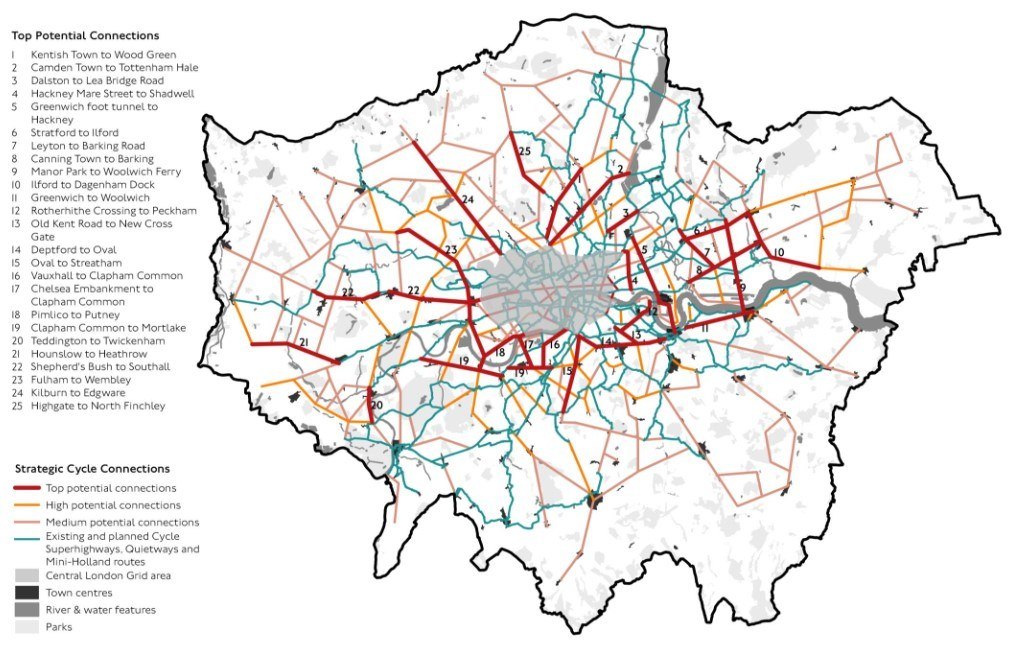
Unlike the two previous plans discussed, the Strategic Cycling Analysis and its CFR map are still officially alive, despite being somewhat forgotten. However, just like the others, proposals for new CFR routes slowly continue to surface, often led by councils. For example, LB Newham has started construction on a cycleway called Cycle Future Route 7. Alongside this, the Streatham Hill Cycleway and the new tracks along Nine Elms Lane – both of which started construction last year – are sometimes referred to as Cycle Future Routes 15 and 16, respectively. Currently the CFR Top 25 network is about 14% complete, with projections suggesting it may reach 34% by 2030.
The most recent appearance of the CFR map was within the 2023 Cycling Action Plan 2. This means that it is probably the closest guide we have of the future, loosely showing what a comprehensive city-wide cycle network for London might look like. However, it doesn’t mean that the parts of the Central London Grid and Cycle Superhighways plan not featured on the CFR map, will not independently continue to be delivered by councils.
Conclusion
Does this mean then that all of these plans will happen, but just incredibly slowly? Sadly not. Rather, the financial position of TfL and most councils makes them too anxious to commit to any idea of a comprehensive city-wide cycle network. Instead, willing authorities will do what they can, building small sections of segregated cycle track and connecting backstreet routes with wayfinding and/or parallel crossings.
In fact, since COVID, all TfL has been able to fully commit to is the 2023 Cycling Action Plan 2’s ‘planned expansions’ (see below). But this only displays cycleways that are already quite far in the design/construction process, rather than acting as a blueprint for what things should look like in future.
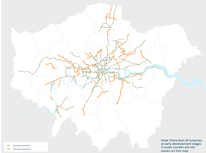
So what do the 2030s and 2040s look like when it comes to London’s cycle network? Well, it is safe to say – bar a massive political upheaval – that if things carry on the way they have, elements of all three plans will continue to develop and should be around 75% complete by 2040. TfL will likely focus on leading the development of ‘Top’ corridors of the Strategic Cycling Analysis, while councils (specifically the pro-cycling boroughs) will continue to apply for Local Implementation Plan money for their own routes, many of which will be based on the institutional memory of all three proposed networks. After all, the CS plan, the CLG and the SCA have all embedded themselves in local plans, Section 106 agreements, regeneration commitments and funding streams from other national infrastructure projects: HS2, the Thames Tideway Tunnel and the Heathrow Third Runway Expansion.
Sadly, we must accept (at least for now) that London’s unbalanced distribution of local government power – often giving councils the final say – prevents TfL (or the GLA) from pursuing a truly comprehensive cycle network as rigorously as Anne Hidalgo has in Paris. TfL simply doesn’t have enough control over London’s roads, which is crazy given there’s now 1.5 million daily cycle journeys on them. Unfortunately, if things carry on this way, it will result in an inconsistent network by 2040: world-leading in some boroughs, sub-par in others.
Aydin Crouch

